by Barbara J. Wood
WILSON COUNTY TEXAS MISSIONS
LOCATIONS OF THE SAN ANTONIO MISSION'S RANCHOS
... Extensive research locating the ranchos of the San Antonio Spanish missions has been conducted and the locations hypothesized for many decades. Of the 6 San Antonio missions that resided along the San Antonio River in Bexar County, five of those missions had ranchos that were located approximately 20-30 miles from the mission they were tasked to sustain. Only Mission San Antonio de Nuxara, which only existed for four years, did not have a dedicated rancho for its food and meat for the mission. The rest of the ranchos were located in Bexar and neighboring counties. One rancho was in Bexar County, one rancho was located in Atascosa County, and three ranchos were located in Wilson County.
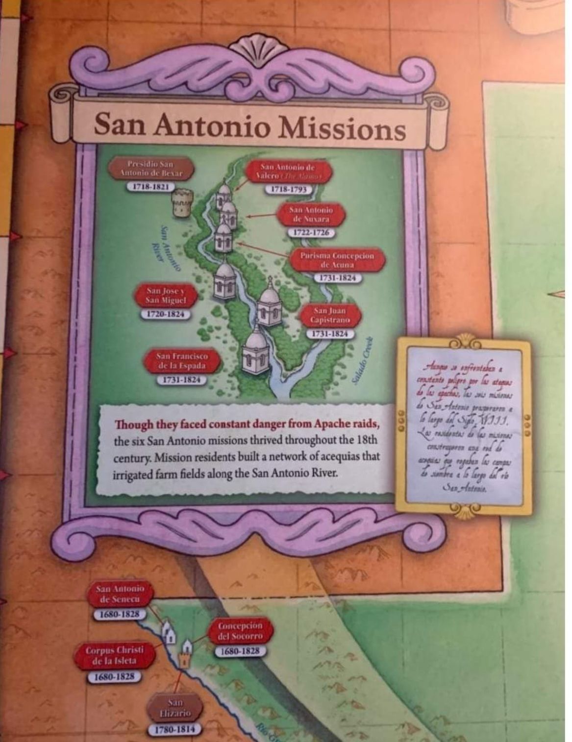
To give us a better understanding of these Spanish missions and their associated ranchos, here is a list of those 6 missions that were and are located in San Antonio.
1. Mission San Francisco de la Espada. 1731-1824. Rancho de las Cabras in Wilson County.
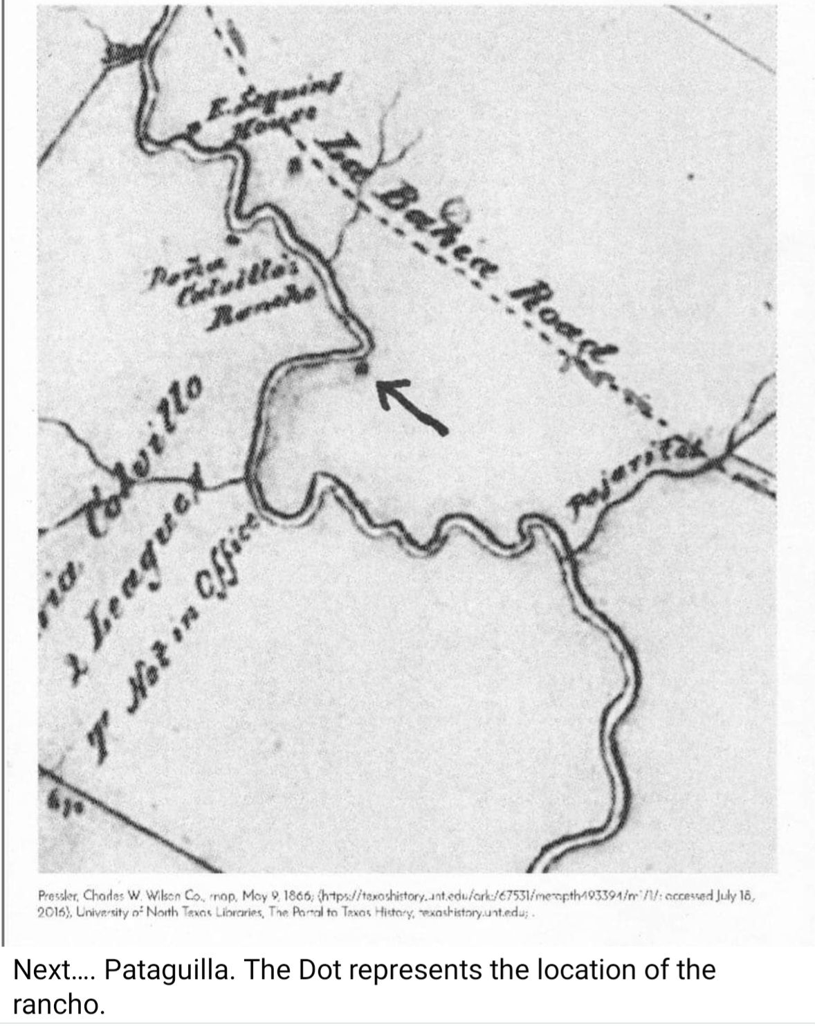
2. Mission San Juan Capistrano. 1731-1824. Rancho de Pataguilla in Wilson County.
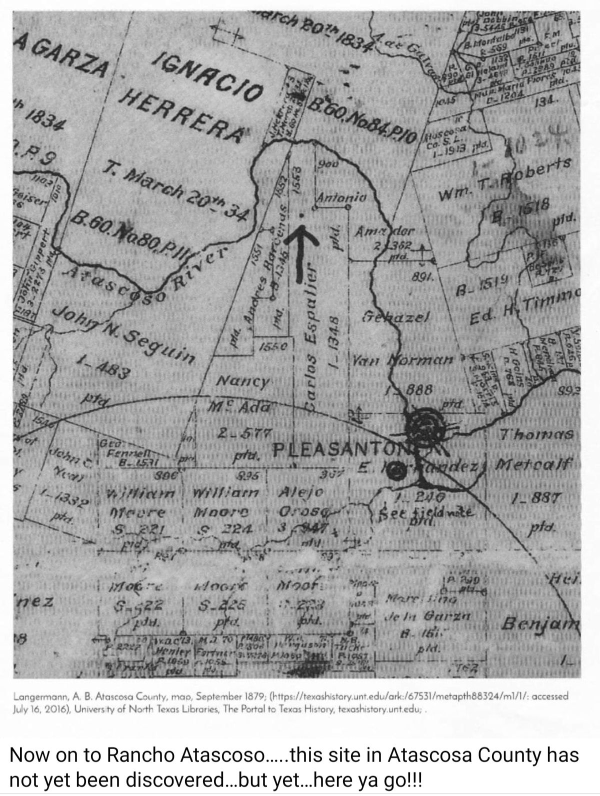
3. Mission San Jose y San Miguel. 1720-1824, Rancho Atascoso in Atascosa County.
4. Mission Purisma Concepcion de Acuna. 1731-1824. Rancho de Paistle in Wilson County.
5. Mission San Antonio de Nuxara. 1722-1726. No Rancho associated with it. No evidence remaining of the mission.
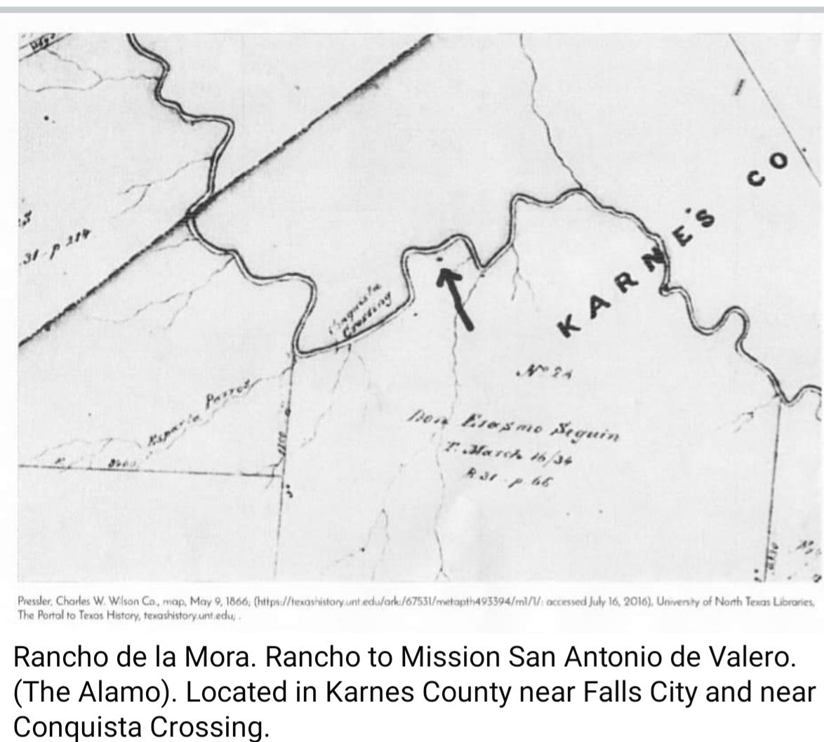
6. Mission San Antonio de Valero (The Alamo). 1718-1793. Rancho de la Mora in Karnes County,
These ranchos had the responsibility of raising horses for any task needed, raising the goats and cattle for meat the mission needed for sustenance, and providing a safe refuge for its habitants, vaqueros, and any neighbors seeking safe-haven against native Lipan Apache Indian attacks along with providing social, religious, and economic platforms.
The only rancho out of all five that has any evidence remaining is Wilson County's "Rancho de las Cabras".
However, extensive research into each of these historical remnants has been shut out by the current landowners as to date. Rancho de las Cabras was tasked to provide for Mission Espada. Rancho de las Cabras, just 22 miles south of Mission Espada had over 1,000 cattle and about 4,000 sheep and goats roaming the fields more than 250 years ago. Maria Del Carmen Calvillo, gained ownership and control of the property. Calvillo left behind a great legacy of her own success at the ranch. She was known for her "independent spirit," and she frequently defied the social norms of Spanish and Mexican society. She traded meat from her ranch with local Native Americans to relieve some of the tensions between the two groups. She maintained control of the land until she passed away in 1856. After Calvillo's death, the land went to two of her children. An interesting factoid is that historians credit Rancho de Las Cabras as the birthplace of the Cowboy culture (vaqueros). Of all the ranchos, Rancho de las Cabras has the most heritage, history, factual existence, and most flamboyant stories. The ranchlands stretched in an arc about 20 to 30 miles to the north and south of the missions along both sides of the river. Mission San Antonio de Valero had Rancho de la Mora and, after the 1760s, shared Rancho de Monte Galvan with Concepción and San Juan. These ranchos were begun in the 1740s, and peaked in the 1750s and 1760s when full title to the lands were sought by each mission.
Now on to the locations of these ranchos. Where were the ranchos and why did the vaqueros establish their foothold for these ranchos where they did? It must be emphasized here, that this author is hypothesizing as to the methodology, reasoning, and tactical significance of each of these rancho's location. This has not been proven, debated, validated, or even discussed among historical scholars, as this author is not a scholar of historical ranks, but careful examination of the purported evidence is substantiated by geographical placement of the ranchos and a repeated pattern of topographical evidence of each of these ranchos does validate this hypothesis. A repeated pattern offers substantial consideration for proof of methodology in regard to placement for each one of these ranchos. What does this mean? It means that these ranchos were not arbitrarily placed. It means that topography played into the tactical and geographic ranching decisions. Careful placement of these ranchos into a specific geographic area was the greatest accomplishment the missions could ever do, which led to their success.
To make this concise, the following maps will show a repeated pattern of methodology in placement of the ranchos. A bold claim to make at this point is that even a dot on map may have significant importance even if not noted with quotes.
Reader's Digest version: Dots are ranchos. Horseshoes are tactical geographical boundaries. (This will make sense soon.)
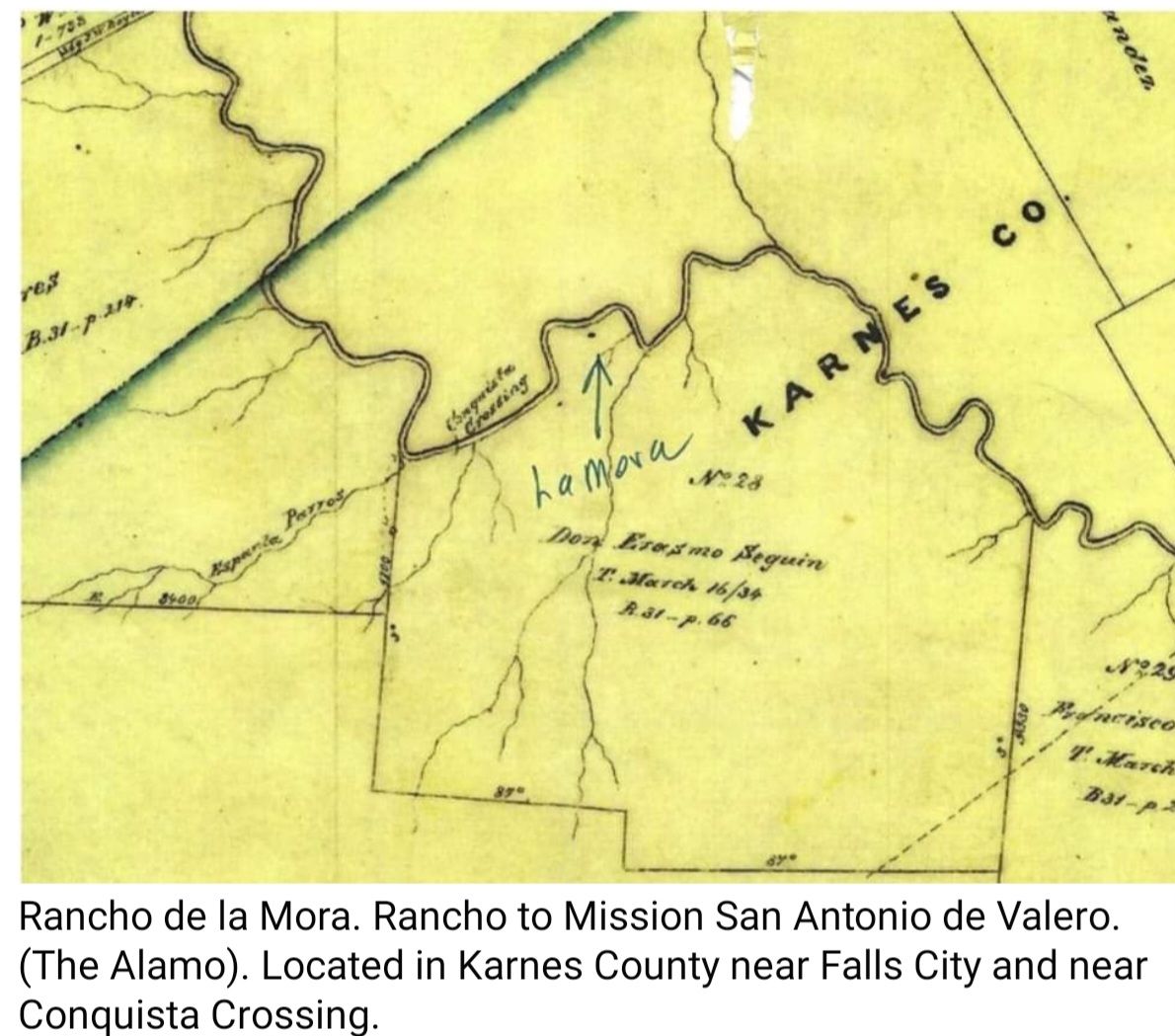
Let's start with Rancho de la Mora. Rancho to Mission San Antonio de Valero. (The Alamo). Located in Karnes County near Falls City and near Conquista Crossing.
Rancho de la Mora was located along the banks of the San Antonio River near Falls City in Karnes County near Conquista Crossing. There is little archeological evidence remaining of the site. However, Google Earth photos still capture its existence. Notice the horseshoe river bend with the rancho encapsulated within. Vaqueros had to only protect one avenue of entry into the site, while the other three sides were protected by geographical boundaries of the river. 3:1 tactical aspect ratio which also meant it was easier to control the livestock. If an attack was conducted by Lipan Indians, their combat ratio was cut by ¾ because of the placement of the rancho along the river which protected them along three sides. La Mora is depicted by a sole dot. This is not uncommon in mapping and topography in these times. La Mora can be mapped on Google Earth and its outline can still be found. La Mora and its connection to the Alamo is profound and is not being capitalized on. La Mora is a gold mine and the remnants that may be found there are beholding to the finder.
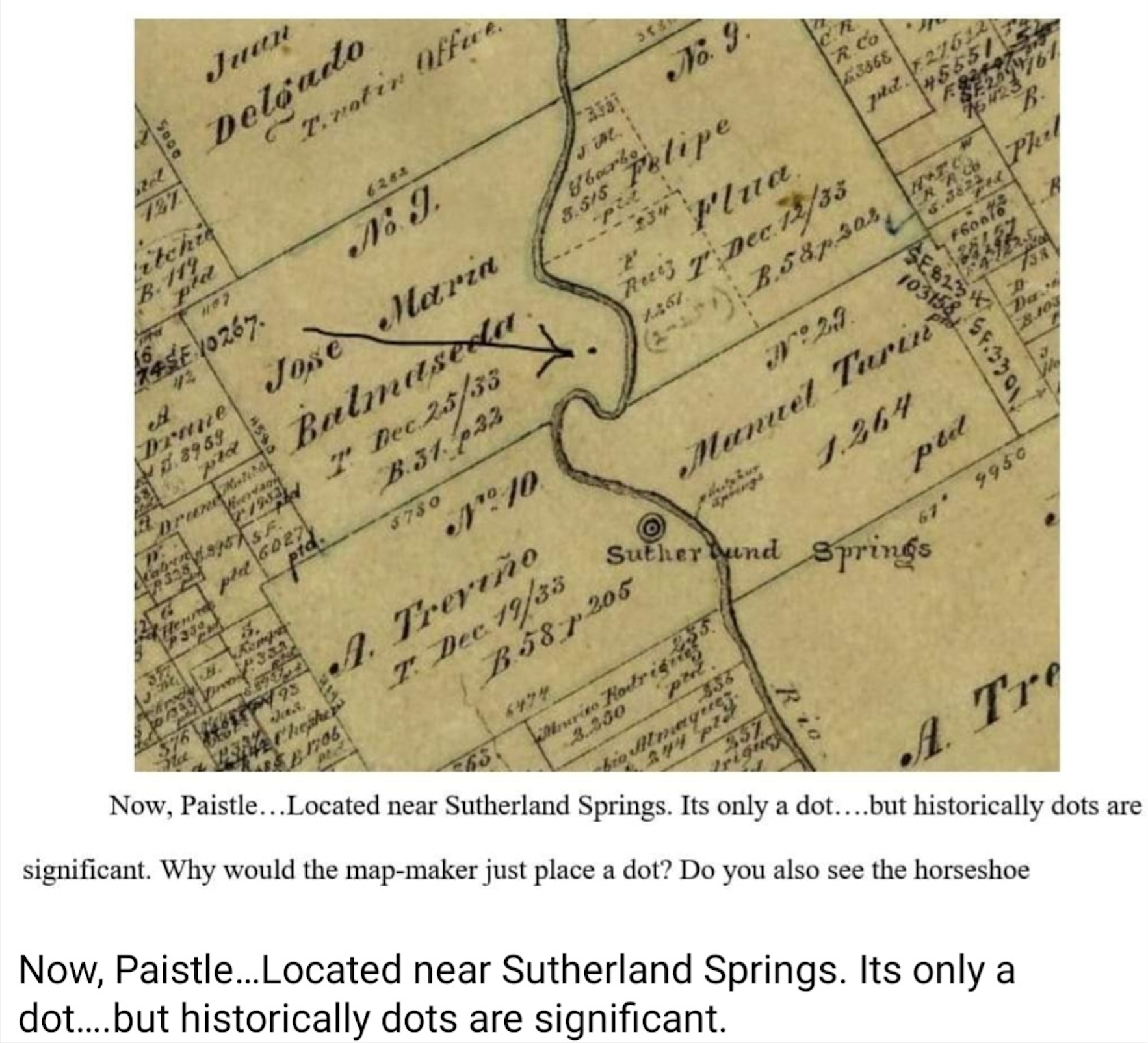
Now, Paistle...Located near Sutherland Springs. Its only a dot....but historically dots are significant. Why would the map-maker just place a dot? Do you also see the horseshoe geographic positioning of the rancho by the river? Why guard 4 sides when we should only guard 1? 3:1 tactical aspect ratio again. Open range livestock are guarded on all 4 sides with only one being fortified by vaqueros. Geography plays a part in ranching. The Balmaseda land grant in regards to the rancho is still being debated by legal authorities and historians. Time will tell....but it is of this author's opinion that the rancho does lie on the Balmaseda land grant.
Next.... Pataguilla. The Dot represents the location of the rancho. Maurine Liles research and historical marker application reflect more information upon this. Yet, the rancho is situated
on the edge of the horseshoe. Do you see the strategic placement of the rancho in regards to the geographic horseshoe? Well done Vaqueros!!!
Now on to Rancho Atascoso.....this site in Atascosa County has not yet been discovered...but yet...here ya go!!! The evidence is offered to you. Mission San Jose is considered the crown jewel of the missions of San Antonio but little is discussed about the rancho because of the rich heritage of the mission itself. In communication with Atascosa Historical Society, they state they do not know the location of Rancho Atoscoso. Applying geographical, historical, and repetitive application to other ranchos, we can identify where Rancho Atoscoso is. They can believe me or not....but the historical repetitive evidence is profound.
All of the ranchos according to these historical maps exhibit a common trait...they all are within a "horseshoe" bend of the river to encapsulate 3 sides of a fortified position which means that an attack can only occur from one side, and that livestock have only one way to be corralled, and that livestock are "fenced in" on three sides with only one side for the vaqueros to tend to. This is a tactical, strategic, and geographic advantage.
Have you heard of the ghost of Maria Del Carmen Calvillo and the Rancho de las Cabras?????? Does she still ride her white horse at night? Yes she does!!!
***********
Researched, authored, & shared by Wilson County Historian Mark Cameron